
< Back To Index From 2014 Hurricane Season
CLICK HERE TO GO TO 2015 SEASON
2014 Atlantic Hurricane Season Ended On December 1st
Click
On
STORM NAME
For The Latest Information Available![]()
This Link Takes You To MSNBC's Hurricane Tracker
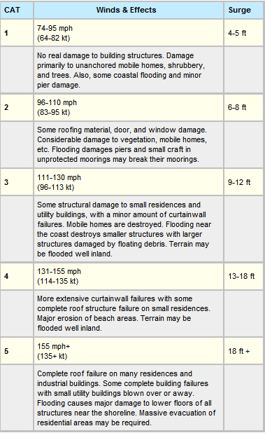
Activity Reference Chart For Atlantic - Caribbean Sea - Gulf of Mexico
Click On 24/7 Time Marked Live Picture At Right To Stream East Into Atlantic Ocean From The Florida Keys
| STATUS | # | NAME | DATE NAMED |
MAX SUSTAINED WIND SPEED (MPH) (LIFE OF STORM) |
MAX FORWARD WIND SPEED (MPH) (LIFE OF STORM) | HURRICANE CATEGORY REACHED | AFFECTED LAND |
| END 7/5 | 1 |
ARTHUR First Storm / Hurricane 2014 |
07/01/2014 | 100 | 31 | 2 | FL, SC, NC |
|
END 8/5 |
2 | 07/31/2014 | 80 | 24 | 1 |
Antilles, Puerto Rico, Haiti. Bahamas |
|
| END 8/29 | 3 | 08/24/2014 | 85 | 46 | 1 |
Lesser Antilles, Puerto Rico, Virgin Islands, Bahamas |
|
| END 9/3 | 4 | 09/01/2014 | 50 | 16 |
Mexico |
||
| END 9/19 | 5 | 09/11/2014 | 115 | 30 | 3 |
Corner Islands |
|
| END 10/13 | 6 | 10/10/2014 | 75 | 29 | 1 |
Bermuda |
|
| END 10/20 | 7 | 10/12/1014 | 145 | 52 | 4 |
Bermuda, Ireland, United Kingdom |
|
| END 10/28 | 8 | 10/27/2014 | 40 | 7 |
Nicaragua |
||
|
Next Storm Name - Isaias |
Storm Notification Provided By Tracking The Eye.Net Non-Colored Storm & Land Names Indicate Forming Storms & Projections
Click Here To Go To World Sunlight Map Click Here To Go To Earth At Night
![]()
![]()
Map Above Courtesy Of: http://www.wunderground.com/

![]()
Click On Map Above To Go To NAVAL ATLANTIC OCEANOGRAPHY CENTER Maps
Map Above Courtesy Of: http://www.AccuWeather.com 3 Hour Max Delay
Click On Map Then Mouse Over Activity Circles For Expanded Storm Information
Map Above Courtesy Of: National Hurricane Center
2014 Atlantic Hurricane Names
Isaias
Josephine
Kyle
Laura
Marco
Nana
Omar
Paulette
Rene
Sally
Teddy
Vicky
Wilfred
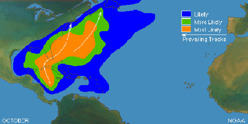
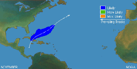
Click On Likely Track Charts For More Information
\

All Hurricane Archive Data Since 1851
| STATUS | # | NAME | DATE NAMED |
MAX SUSTAINED WIND SPEED (MPH) (LIFE OF STORM) |
MAX FORWARD WIND SPEED (MPH) (LIFE OF STORM) | HURRICANE CATEGORY REACHED | AFFECTED LAND |
| 1 | 06/05/2013 | 65 | 39 | Florida, Georgia, South Carolina, North Carolina, Virginia, Maryland, Delaware, New Jersey, New York, Connecticut, Rode Island, Massachusetts (End Tracking) | |||
| 2 | 06/19/2013 | 40 | 13 | Belize, Guatemala, Yucatan Peninsula, S SE Mexico | |||
| 3 | 07/08/2013 | 65 | 29 | Lesser Antilles | |||
| 4 | 07/24/2013 | 60 | 23 | None | |||
| 5 | 08/15/2013 | 40 | 17 | None | |||
| 6 | 08/25/2013 | 40 | 12 | Mexico | |||
| 7 | 09/04/2013 | 50 | 17 | Lesser Antilles, Leeward Islands, Virgin Islands, Puerto Rico, Hispaniola, Bermuda | |||
| 8 |
HUMBERTO First 2013 Hurricane |
09/09/2013 | 85 | 15 | 2 | Africa, Cape Verde Islands | |
| 9 | 09/13/2013 | 75 | 8 | 1 | Mexico | ||
| 10 | 09/28/2013 | 40 | 7 | Azores | |||
| 11 | 10/03/2013 | 65 | 12 | Western Caribbean, Jamaica, Cuba, NE Yucatan Peninsula, Cayman Islands, Gulf Of Mexico Oil Rigs, Florida, Alabama, Mississippi Louisiana | |||
| 12 | 10/21/2013 | 50 | 9 | None | |||
| 13 | 11/18/2013 | 65 | 30 | Cape Verde Islands |
Storm Notification Provided By Tracking The Eye.Net Non-Colored Storm & Land Names Indicate Forming Storms & Projections
Map Below Courtesy Of: wunderground.com
![]()
Last Page Update: Sunday, 19. June 2022 08:41:41 AM, CDT Imported Charts Updated By Provider, All Current.
