
THIS PAGE IS ARCHIVED. PLEASE CLICK HERE TO VISIT THE INDEX.
CLICK HERE TO GO TO 2013 HURRICANE SEASON
2012 Hurricane Season Ends Friday November 30th
Activity Reference
Chart For Atlantic - Caribbean Sea - Gulf
of Mexico
Click On Storm
NAME
For
The Latest Information Available![]()
This Link Takes You To MSNBC's Hurricane Tracker
| STATUS | # | NAME | DATE NAMED |
MAX SUSTAINED WIND SPEED (MPH) (LIFE OF STORM) |
MAX FORWARD WIND SPEED (MPH) (LIFE OF STORM) | HURRICANE CATEGORY REACHED | AFFECTED LAND |
| 1 |
ALBERTO (TS) First 2012 Storm |
05/19/2012 | 50 | +17 | NC, SC, GA Costal Region | ||
| 2 | 05/25/2012 | 70 | +10 | SC, GA, FL, NC, VA, AL, VA, DE | |||
| 3 |
CHRIS First 2012 Hurricane |
06/19/2012 | 75 | +22 | 1 | NONE | |
| 4 | 06/23/2012 | 60 | +6 | Fl, GA, AL, | |||
| 5 | 08/02/2012 | 85 | +24 | 1 | Windward Islands, Barbados, Belize, Yucatan Peninsula, S SE Mexico | ||
| 6 | 08/04/2012 | 60 | +16 | NONE | |||
| 7 | 08/16/2012 | 111 | +22 | 3 | Azores | ||
| 8 | 08/17/2012 | 45 | +7 | Mexico | |||
| 9 |
ISAAC |
08/21/2012 | 80 | +25 | 1 | Lesser Antilles, Puerto Rico, Dominican Republic, Haiti, Jamaica, Cuba, Turks & Caicos Islands, Bahamas, Florida Keys, Gulf Oil Rigs, Alabama, Mississippi, Louisiana | |
| 10 | 08/22/2012 | 40 | +17 | NONE | |||
| 11 | 08/28/2012 | 105 | +13 | 2 | NONE | ||
| 12 | 08/30/2012 | 75 | +21 | 1 | Bermuda, Nova Scotia, Newfoundland, Greenland, Iceland | ||
| 13 | 09/04/2012 | 115 | +7 | 3 | NONE | ||
| 14 | 09/11/2012 | 80 | +23 | 1 | Galapagous Islands, Azores | ||
| 15 |
OSCAR (TS) |
10/03/2012 | 40 | +15 | NONE | ||
| 16 |
PATTY (TS) |
10/11/2012 | 45 | +S | Bahamas | ||
| 17 | 10/12/2012 | 90 | +35 | 1 | Lesser Antilles, Virgin Islands, Puerto Rico, Bahamas, Bermuda, | ||
| 18 | 10/22/2012 | 105 | +22 | 2 | Caribbean, Hispaniola, Jamaica, Eastern Cuba, Bahamas, NE USA | ||
| 19 | 10/22/2012 | 50 | +25 | Azores | |||
|
Valerie |
Storm Notification Provided By Tracking The Eye.Net Non-Colored Storm & Land Names Indicate Forming Storms & Projections
Click To Go To Satellite Imagery With World Night Lights
The Maps
Below Are Refreshed Constantly
And Remain Active 24 Hours / 365 Days![]()
![]()
![]()
Map Above Courtesy Of: http://www.wunderground.com/

![]()
Click On Map Above To Go To NAVAL ATLANTIC OCEANOGRAPHY CENTER Maps
Map Above Courtesy Of: http://www.AccuWeather.com 3 Hour Max Delay
Map Updates With A Disturbance
Click On Map Then Mouse Over Activity Circles For Expanded Storm Information
Map Above Courtesy Of: National Hurricane Center
Remaining 2012 Atlantic Hurricane Names
Valerie
William
Click History Charts To Enlarge
Total # Of Hurricane Strikes Total # Of Major Hurricane Strikes
![[Map of 1900-2010 Hurricane Strikes by U.S. counties/parishes]](http://www.nhc.noaa.gov/climo/images/strikes_us.jpg)
![[Map of 1900-2010 Major Hurricane Strikes by U.S. counties/parishes]](http://www.nhc.noaa.gov/climo/images/strikes_us_mjr.jpg)
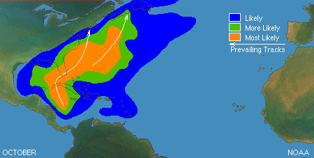
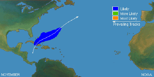
Click On Likely Track Charts For More Information
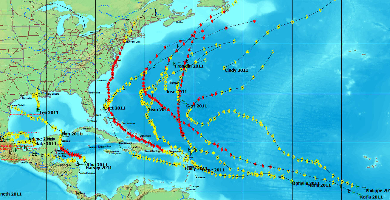
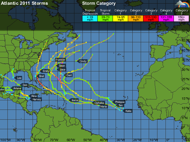
2011 Hurricane News (Last Entry 8/30/2011)

All Hurricane Archive Data Since 1851
2011 Hurricane Season Reference Charts
Activity Reference Chart For Atlantic - Caribbean Sea - Gulf of Mexico
| STATUS | # | NAME | DATE NAMED |
MAX SUSTAINED WIND SPEED (MPH) (LIFE OF STORM) |
MAXIMUM WIND GUST (MPH) (LIFE OF STORM) | CATEGORY REACHED | AFFECTED LAND |
| Archive | 1 |
ARLENE (TS)First 2011 Storm |
6/28/2011 |
65 | Mexico | ||
| Archive | 2 |
7/17/2011 |
65 | Bahamas | |||
| Archive | 3 |
7/20/2011 |
60 | None | |||
| Archive | 4 | 7/27/2011 | 50 | Mexico, Texas | |||
| Archive | 5 | 8/01/2011 | 50 |
Lesser Antilles Northern Windward Islands, Leeward Islands, Puerto Rico, Dominican Republic, Haiti, Bahamas |
|||
| Archive | 6 | 8/13/2011 | 45 | None | |||
| Archive | 7 | 8/14/2011 | 60 | Bermuda | |||
| Archive | 8 | 8/19/2011 | 60 | Honduras, Nicaragua, Belize, Eastern Yucatan Peninsula, Cabo Gracias | |||
| Archive | 9 | 8/20/2011 | 120 | 150 | 3 |
Leeward Islands, Lesser Antilles, Virgin Islands, Puerto Rico, Dominican Republic, Haiti, US & British Virgin Islands, Turks & Caicos Islands, Bahamas, SC, NC, VA, DE, MD, NY, NJ, CT, MA, VT, NH, ME, Canada, Greenland, Iceland |
|
| Archive | 10 | 8/28/2011 | 40 | None | |||
| Archive | 11 | 8/30/2011 | 131 | 140 | 4 | UK, Faroe Islands, Shetland Islands | |
| Archive | 12 | 9/02/2011 | 60 | Gulf Oil Rigs, Louisiana, Mississippi, Florida, Alabama | |||
| Archive | 13 | 9/07/2011 | 75 | 124 | 1 | Northern Windward Islands, Leeward Islands, Puerto Rico, Bermuda, Newfoundland | |
| Archive | 14 | 9/07/2011 | 70 | 83 | 1 | Mexico | |
| Archive | 15 | 9/21/2011 | 120 | 143 | 3 | Northern Leeward Islands, Bermuda | |
| Archive | 16 | 9/24/2011 | 85 | 115 | 1 | Iceland | |
| Archive | 17 | 10/23/2011 | 110 | 123 | 2 | Mexico (Yucatan Penensula), Cuba | |
| Archive | 18 |
SEAN (TS) |
11/08/2011 | 65 | Bermuda |
Last Page Update: Sunday, 19. June 2022 08:41:35 AM -0600 Imported Charts Updated By Provider, All Current.
